Wesleyan Chapel
The chapel shown in the photograph below was the second Wesleyan Chapel, it was built in 1880 because the original was deemed to be too small. It was on two floors with services held on the upper floor and Sunday school on the lower one. It was demolished at the end of the 1980s after being condemned due to dry rot. The original chapel still stands and is now used by the sea cadets, this earlier chapel was built in 1866.

Bridge Street
This picture of Bridge Street, taken around 1905, shows how little has changed in over a century. The shop on the left belonged to Rowland King, local photographer, and the man responsible for many postcards featuring Newton-le-Willows landmarks. Diagonally opposite King’s shop, on the site of the current Royal Mail sorting office stood a coal yard belonging to Richard Evans of Haydock. Bridge St continues to be a thriving part of the centre of Earlestown, being the home to many local shops and businesses. The architecture of the original shops as shown above is still visible in many cases, although inevitably many have changed purpose and occupiers innumerable times since.

Ronayne’s Bungalow
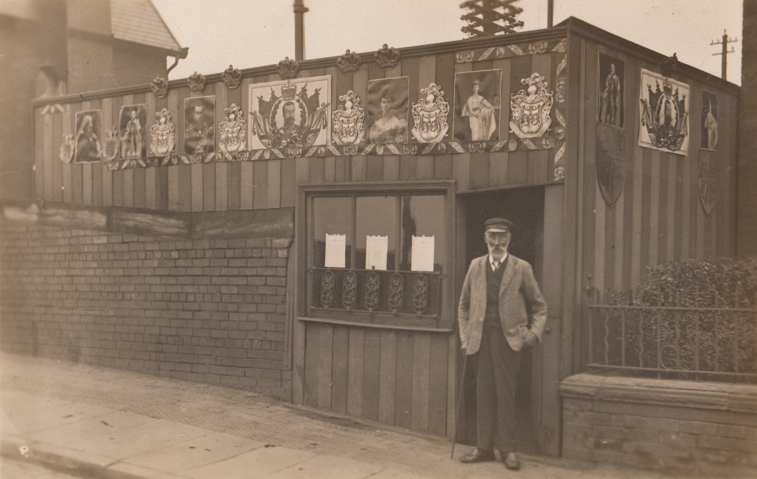
Here is Garret Ronayne standing proudly outside his bungalow situated on the same location as the interpretation board, which he had decorated for the visit of King George V in 1913. He was an Indian Mutiny Volunteer, poet and well-known local character. A year previous to this photograph the 79 year old published his autobiography. He was a man who stuck firmly to his principles, even going so far as to have his grave stone erected in the Cemetery before his death to ensure that his wish to be buried there would be honoured after his death. He fought a long battle with the local council over his bungalow as the Council considered it an illegal structure and wanted to demolish it.
Haydock Mineral Line
The mineral line ran from the Haydock pits parallel with Haydock Street, under the bridge on Bridge Street upon which you are standing, across Railway Street and down to a wharf near Bradley Lock on the Sankey Canal. It was originally horse drawn and predated the construction of the Liverpool and Manchester Railway, which it crossed at right angles without the use of points. Because this line was built first it retained priority over the later Liverpool to Manchester line. The above picture shows the signal box and the station masters house. In the background is Fairclough Street on which you can see Fairclough’s Mill.
